National Geospatial Internship (jointly organized by FOSSEE GIS (NMEICT) project & The RuDRA Lab, IIT Bombay)
About the National Geospatial Internship (A joint initiative of the IIT Bombay FOSSEE GIS (NMEICT) project & The RuDRA Lab):
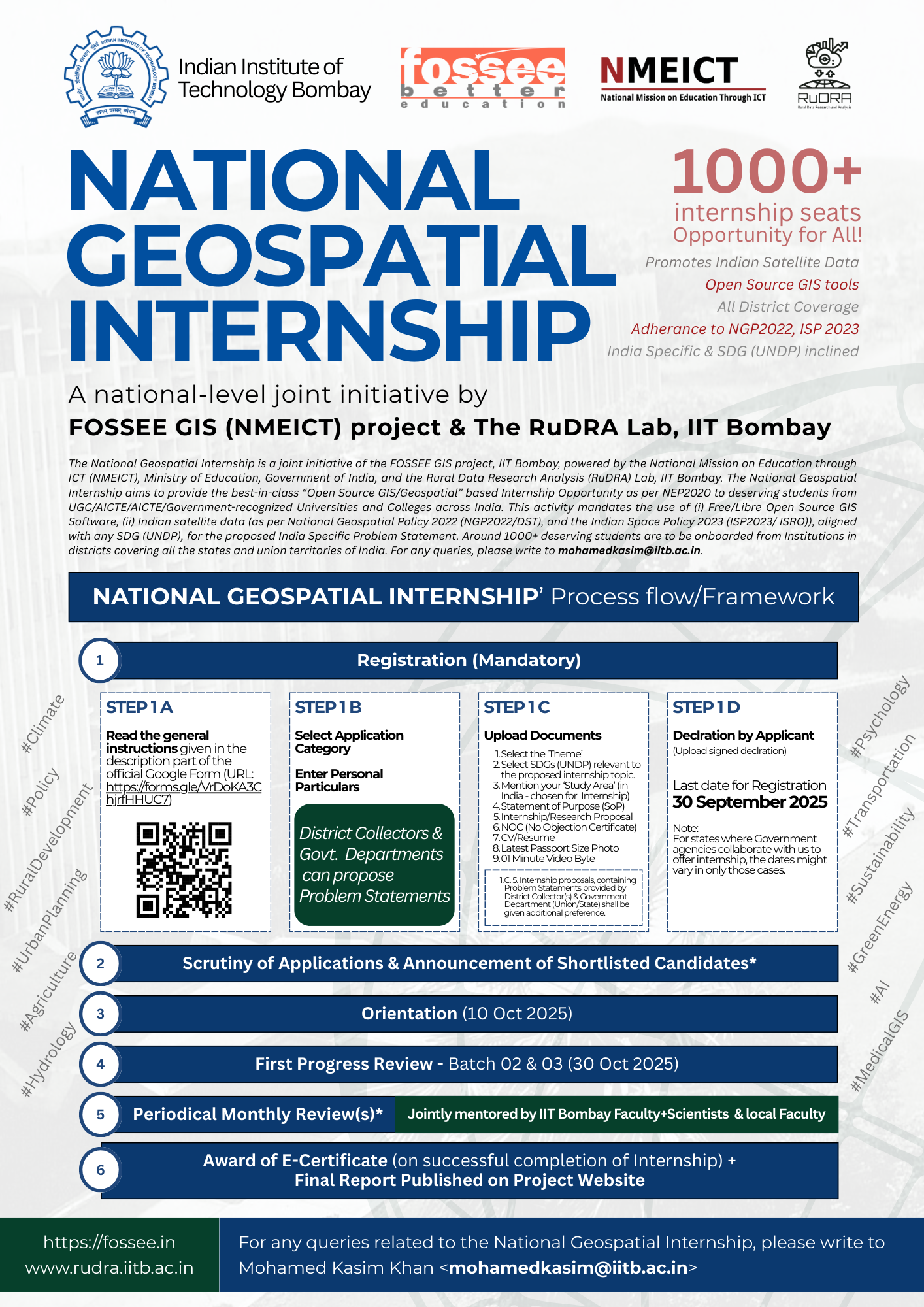
The National Geospatial Internship is a joint initiative of the FOSSEE GIS project, IIT Bombay, powered by the National Mission on Education Through ICT, Ministry of Education, Government of India, and the Rural Data Research and Analysis (RuDRA), Indian Institute of Technology Bombay. The National Geospatial Internship aims to provide the best-in-class “Open Source GIS/Geospatial” based Internship Opportunity as per the National Education Policy 2020 (NEP2020) to deserving students from University Grants Commission (UGC)/AICTE/Association of Indian Universities/Government-recognized Universities and Colleges across India. This activity mandates the use of (i) Free/Libre Open Source GIS Software, (ii) Indian satellite data (as per National Geospatial Policy 2022 (NGP2022/DST), and the Indian Space Policy 2023 (ISRO), use of Shape files from Survey of India, aligned with any SDG (UNDP), for the proposed India-specific Problem Statement. Around 1000+ deserving students are to be onboarded from Institutions in districts covering all the states and union territories of India.
The National Geospatial Internship is conceptualized at IIT Bombay after more than five years of Open Source GIS/Geospatial capacity building efforts through activities like Geospatial Mapathon, Medical GIS Hackathon, IoT-GIS Hackathon, FDPs, and National Geospatial Awards. The focused themes of the National Geospatial Internship include (i) Rural Development, (ii) Hydrology/Water, (iii) Agriculture, (iv) Urban Planning, (v) Artificial Intelligence, (vi). Medical GIS, (vii) Green Energy and Sustainability, (viii) Artificial Intelligence in GIS, (ix) Transportation, (x) Climate, (xi) Policy, etc. There will be state-wise partners (University/State Government Department(s)) identified to ensure wider coverage and to obtain real-life problem statements from District Collectors, etc. The National Geospatial Internship is aimed at providing an opportunity to all who are inclined towards Open Source GIS tools, promoting Indian satellite data in academic institutions and industry across India. Interns will be selected through a unique NGI process-flow/framework, which shall ensure opportunity is given to the candidate with the right skill-set, and a proposal that shall result in a good thematic map-based solution addressing common issues faced in the Indian context. Thus, ensuring the propagation of Open Source Geospatial tools, the use of Indian satellite data in compliance with all national policies enacted from time to time. For any queries related to the National Geospatial Internship, please write to the National Geospatial Internship Coordinator, Mohamed Kasim Khan M at <mohamedkasim@iitb.ac.in>
Important Dates:
- Announcement of Internship: 01 July 2025
- Registration Start Date: 01 July 2025
- Last date for Registration: 30 September 2025
- Orientation and Onboarding of Interns: 01 October 2025
Official URL: https://fossee.in/NGI2025
Please read the instructions carefully before filling out the National Geospatial Internship's Registration form.
- Use of Open Source Software, and Indian satellite data (ISRO's platforms, i.e., Bhuvan, Bhoonidhi, VEDAS, MOSDAC, etc) is mandatory
- Last day to register via this form: 30 September 2025. There won't be any extension.
- District Collectors and Government Departments (Union/State/UT) can propose Problem Statements.
- Duration of the "National Geospatial Internship": 06 months (max). The FOSSEE GIS team shall decide on the tenure of the internship based on the i. Problem Statement: ii. Statement of Purpose (SoP); iii. CV; iv. NOC (from the Head of the Institute/Department) of the applying candidate. There shall be a local mentor identified at the time of application.
- The Applicant must be a bona fide student of any UGC/AICTE/AIU/Union/State Government recognized institute or organization from India.
- Recent College pass-outs with a qualifying degree and required skill sets, if present, can apply. But preference shall be given to the current students.
- Opportunity for Everyone! As a token of appreciation to the institutions that have implemented the National Education Policy 2020 (NEP2020), we have decided to keep the number of internships to be offered as 1000. This count shall be evenly distributed (for problem statements), covering all districts of India.
- Detailed instructions shall be given to the shortlisted candidates during the orientation, when scheduled.
- SoP (Statement of Purpose) needs to be submitted along with this form.
- Candidates will be shortlisted based on their eligibility, qualification, and their knowledge in QGIS or any Open Source-based GIS tool (including Dashboard creation). All Institutions will be treated equally. Preference will be given to Pre/Final year students.
- The award winners of the National Geospatial Awards 2024 (Edition 01) and National Geospatial Awards 2025 (Edition 02) can directly nominate their students for the National Geospatial Internship by making their students fill out the form and send us an email with the list of students (mohamedkasim@iitb.ac.in) they will be guiding.
- The Champions, Winners of (i) IIT Bombay FOSSEE Geospatial Mapathon 2024 (Edition IV) and (ii) IIT Bombay FOSSEE-AAI Geospatial Mapathon 2025 (Edition V) are strongly encouraged to apply.
- Only individual participation is allowed for a single internship certification.
- NOC is mandatory for all applicants.
- There is "NO FEE" involved to apply for the internship.
- The National Geospatial Internship (Batches 01, 02 & 03) shall be conducted fully in 'Remote Mode'.
- Shortlisted candidates will be informed via email. Mere being shortlisted doesn't make anyone automatically eligible for the award of the e-certificate. The candidate, once selected, must complete all required tasks within the prescribed timeline.
- Periodical progress reports, along with an online (recorded) presentation, must be made by each selected Intern/ Summer fellow, monthly, to the IIT Bombay FOSSEE GIS team.
- e-certificates will ONLY be awarded on successful completion of activities. Prolonged absence and lack of quality output by the candidates/ prospective interns/ summer fellows will result in disqualification from the program.
- The final report of the candidate completing the internship (if approved by the team) shall be uploaded to the project website. (Standard Creative Commons, etc policies apply).
- The candidates and the mentors, if selected, must adhere to all the FOSSEE GIS mandates at all times.
- The decision of the IIT Bombay FOSSEE GIS (NMEICT) and the RuDRA Lab teams shall be final and non-appealable.
- All general queries related to the National Geospatial Internship must only be addressed to the National Geospatial Internship Coordinator, Mohamed Kasim Khan, at mohamedkasim@iitb.ac.in.
Featured THEMES for National Geopatial Internship 2025
+ Rural Development
+ Agriculture and allied fields
+ Water/Hydrology
+ Medical GIS (One Health)
+ GIS in Psychology
+ Artificial Intelligence in GIS
+ Green Energy and Sustainability (Electric Vehicle)
+ Urban Planning
+ Climate and Disaster Management
+ Under Ocean Exploration
+ Waste to Wealth
+ Mountain Ecosystem and Economics
+ Transportation
FOSSEE GIS Mandates:
To participate in any of the FOSSEE GIS activities, the participating individual/team(s)/Institutions must follow the mandates as listed below:
- Indian Citizens Only.
- The participant(s) must be bona fide students/faculty/staff of the institution recognized by UGC/AICTE/AIU or a body recognized by the Union and/or State Government.
- Use only Free/Libre Open Source Software/Open Source Hardware.
- Activity must align with at least one SDG (UNDP).
- The study area should be India-specific.
- Work on real-life data sets based on the Indian context.
- Datasets must be “non-sensitive” and from a “genuine/valid source”.
- Adhere to the (Indian) National Geospatial Policy 2022 and Indian Space Policy 2023.
- Use shapefiles from the Survey of India Portal ONLY.
- Use Indian satellite data from ISRO-NRSC’s MOSDAC, Bhuvan, Vedas, Bhoonidhi portals, and indigenous Indian technologies like NavIC, etc.
- Problem statements can be inclined toward the PM Gati Shakti Portal (recommended).
- The qualified entries of all IIT Bombay FOSSEE GIS (NMEICT) initiatives shall be released under the Creative Commons (CC-BY-SA or related) license.
The National Geospatial Internship 2025 is organized jointly by the FOSSEE GIS project, IIT Bombay, and the RuDRA Lab, IIT Bombay. Conceptualized by Mohamed Kasim Khan M (National Coordinator - FOSSEE GIS (NEMICT), IIT Bombay) under the guidance of Prof. Kannan Moudgalya and Prof. Pennan Chinnasamy, Co-PI and GIS lead.
Email: mohamedkasim@iitb.ac.in